ePrints
Map of the settled part of V.D.L.,1830, Royal Society of Tasmania Collection
Scott, Thomas and Batman, John 1830
, Map of the settled part of V.D.L.,1830, Royal Society of Tasmania Collection
, Royal Society of Tasmania, University of Tasmania Library Special and Rare Materials Collection, Australia.
![[img]](https://eprints.utas.edu.au/style/images/fileicons/application_pdf.png)
|
PDF
(Map of Tasmania 1830 - small file)
map_tas_batman...pdf | Download (352kB) Available under University of Tasmania Standard License. |
|
|
PDF
(Map 1/12 north west )
map1nw.pdf | Download (5MB) Available under University of Tasmania Standard License. |
|
|
PDF
(Map 2/12 north west)
map2nw.pdf | Download (5MB) Available under University of Tasmania Standard License. |
|
|
PDF
(Map 3/12 north east)
map3ne.pdf | Download (5MB) Available under University of Tasmania Standard License. |
|
|
PDF
(Map 4/12 north east)
map4ne.pdf | Download (5MB) Available under University of Tasmania Standard License. |
|
|
PDF
(Map 5/12 central west)
map5cw.pdf | Download (5MB) Available under University of Tasmania Standard License. |
|
|
PDF
(Map 6/12 central west)
map6cw.pdf | Download (6MB) Available under University of Tasmania Standard License. |
|
|
PDF
(Map 7/12 central east)
map7ce.pdf | Download (6MB) Available under University of Tasmania Standard License. |
|
|
PDF
(Map 8/12 central east)
map8ce.pdf | Download (5MB) Available under University of Tasmania Standard License. |
|
|
PDF
(Map 9/12 south west)
map9sw.pdf | Download (5MB) Available under University of Tasmania Standard License. |
|
|
PDF
(Map 10/12 south west)
map10sw.pdf | Download (6MB) Available under University of Tasmania Standard License. |
|
|
PDF
(Map 11/12 south east)
map11se.pdf | Download (6MB) Available under University of Tasmania Standard License. |
|
|
PDF
(Map 12/12 south east)
map12se.pdf | Download (5MB) Available under University of Tasmania Standard License. |
|
|
PDF
(Map of VDL large file)
map_tas_whole_m...pdf | Download (10MB) Available under University of Tasmania Standard License. |
|
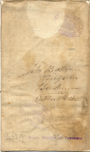
![[img]](https://eprints.utas.edu.au/11284/18/map_back1.jpg)
|
Archive
(Map back 2)
map_back1.jpg | Download (4MB) Available under University of Tasmania Standard License. |
|
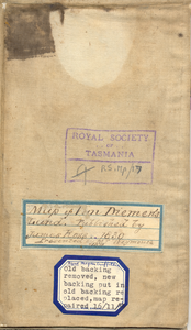
![[img]](https://eprints.utas.edu.au/11284/19/map_back2.jpg)
|
Archive
(Map back 1)
map_back2.jpg | Download (4MB) Available under University of Tasmania Standard License. |
Abstract
T. Scott 1830
Scale: 2cm:10ml 'Map of the settled part of V.D.L. copied from a map in the possession of H.E. Col. G.A. Arthur Lt. Governor. Drawn by Thomas Scott, engraved and published by James Ross 1830 Shows settlements, rivers, police districts (coloured). Endorsed ms. 'John Batman, Kingston, Ben Lomond, October 5th 1830', ink lines and notes of 'fires' probably made by J.B. in re aborigines. (Note by M. Griffiths that 'map repaired with new backing and old backing replaced [1950s]: - map canvas backed & folded)
RS Mp/17
| Item Type: | Other |
|---|---|
| Authors/Creators: | Scott, Thomas and Batman, John |
| Keywords: | RS Map, Tasmania, Royal Society of Tasmania, science, natural science, social history, Australia, indexes, University of Tasmania, Library, private deposits, archives, Collections, catalogue, Special, Van Diemen's Land, map, john batman, thomas scott, aborigines, aboriginal, fire, governor G A arthur, james ross settlements, police districts, rivers |
| Publisher: | Royal Society of Tasmania, University of Tasmania Library Special and Rare Materials Collection |
| Collections: | Royal Society Collection Royal Society Collection > The Royal Society of Tasmania Map Collection |
| Item Statistics: | View statistics for this item |
Actions (login required)
 |
Item Control Page |