ePrints
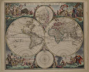
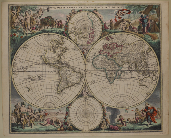
Nova orbis tabula in Lucem Edita. Late 17th century
de Wit, AF 1699
, Nova orbis tabula in Lucem Edita. Late 17th century
, UTAS Special & Rare Collections, The Royal Society of Tasmania, Australia.
![[img]](https://eprints.utas.edu.au/style/images/fileicons/application_pdf.png)
|
PDF
RS-Mp-8.pdf | Download (9MB) Available under University of Tasmania Standard License. |
|
![[img]](https://eprints.utas.edu.au/17564/3/RS-Mp-8.jpg)
|
Image
RS-Mp-8.jpg | Download (9MB) Available under University of Tasmania Standard License. | Preview |
Abstract
'Nova orbis tabula in Lucem edita A.F. de Wit'. Similar to F. de Wit's map of 1660, except for slight revision of coastline of the small portion of Zeelandia Nova shown. The world in two hemispheres with smaller maps of Arctic and Antarctic poles, at top and bottom centre, but the astronomical maps are omitted. Border decorated with bacchanalian scenes, coloured. (cf. Remarkable maps III 6 [RS.Mp.4]) West Australia & Gulf of Carpentaria shown, small part of V.D.L. and small piece of coastline of N.Z.
Size: 55 cm x 46 cm.
RS Mp/8
| Item Type: | Other |
|---|---|
| Authors/Creators: | de Wit, AF |
| Keywords: | RS Map, Tasmania, Royal Society of Tasmania, science, natural science, social history, Australia, indexes, University of Tasmania, Library, private deposits, archives, Collections, catalogue, Special, Van Diemen's Land, world, maps |
| Publisher: | UTAS Special & Rare Collections, The Royal Society of Tasmania |
| Collections: | Royal Society Collection Royal Society Collection > The Royal Society of Tasmania Map Collection |
| Item Statistics: | View statistics for this item |
Actions (login required)
 |
Item Control Page |